If you’re searching for the best hiking in Shenzhen, you’ll be surprised by the variety of scenic trails and mountain hikes this vibrant city offers. Shenzhen hiking isn’t just about escaping the urban rush—whether you’re tackling the iconic Wutong Mountain, exploring the coastal beauty of Qiniangshan, or discovering hidden gems like Yangtaishan and Maluanshan, there’s a Shenzhen hike for every level. From challenging climbs to relaxing walks close to the city center, this guide highlights the top hikes in Shenzhen and provides tips on how to make the most of your outdoor adventure.
Before moving to Shenzhen, China I had never viewed Shenzhen as a place for good hiking, but now I know some of the best hiking spots in Shenzhen. The options I chose are spread across all of Shenzhen, so some are closer and more convenient to get to than others. Happy hiking!
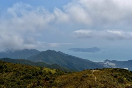
Wutong Mountain, the Tallest in Shenzhen
DIFFICULTY LEVEL: HARD

Wutongshan is the tallest mountain in Shenzhen and located in Yantian, not too far from the bustling centre of Shenzhen. Hiking Wutong mountain gives you sweeping views of the Yantian port, the sea, and other hills and mountains rising in the distance. Wutongshan mountain is an absolute wonder, with lots and lots of steps but also some dirt path options for those more inclined to stray from the main path.
How to Get There
Take metro line 2/8 (orange) and stop at Wutongshan Nan. Disembark. You can follow your map on your phone towards the main entrance or ask someone and they can point it out.
Recommended Route
Dirt Path Route: For those of you interested in getting off of the paved road or the steps, there’s a dirt option that’s not too far out of the way. After exiting the metro, walk towards the main entrance and then make a right on Wutongshan South Road (梧桐山南路). You’ll have to walk on that road for a bit; probably at least 15 minutes. Then you’ll see a dirt path leading up on your left hand side; take it. I love this way. Of course, the main paved way is a great option as well, but have no fear, the dirt path leads to the main trail so it still all connects.

The last leg to the top, with lots of stairs on this Shenzhen hike
Qiniangshan, the Coastal Version of Wutong
DIFFICULTY LEVEL: HARD, BUT FAST

Views while hiking Qiniang

Qinianghan is another hike that’s just full of steps. The ascent is hard, but pretty quick. You initially go up, up, up and then it levels out and provides you with some very stunning views of the sea, as well as the two nearby beaches.
How to Get There
This Shenzhen hike is located in the southwestern Dapeng peninsula of Shenzhen, so you can take public transit, but it is a long journey (3 hours maybe). Take metro line 2/8 to Liantang Port (莲塘口岸) stop, take exit A2, then hop on bus E11. Finally, transfer from the E11 to the M423. Didi is of course always an option, and you can take the metro line to the end and then Didi from there to save a bit of cost. From the M423 bus stop, I just walked until I found what looked like the main entrance, which wasn’t far from the bus stop; there are nice little gardens and resting areas at the bottom. There are likely other entrances as well.
I don’t recommend driving to Dapeng. It is often congested and difficult to find parking.
Dapeng Coastal Hike, Dongchong to Xichong
DIFFICULTY LEVEL: HARD


I think Dongchong to Xichong is by far one of the most beautiful hikes I’ve ever been on (and my limited photos do not do it justice). I hiked from west (xi) to east (dong), but we were largely fighting against people coming from the other direction. Apparently the “correct” path is to go east to west. It starts and ends at a beach, and gives you sweeping views of Shenzhen’s coastline, Hong Kong’s mountains, and the deep, blue sea. The hike is all dirt path and rock hopping, so no stone steps for this one. There are even some chains to help hoist you up and down in some particularly perilous areas.
The hike itself probably took my friend and I about five hours, without taking really any breaks. However, fret not: if you peter out halfway through, there are boats that can take you the rest of the way.
How to Get There
The Dapeng peninsula is a little out of the way from downtown Shenzhen. If you’re willing to shell out the money, a Didi is the best way to go and will take less than 2 hours. Staying the night is pretty much a must unless you want to return late at night.
You can also get there by public transit, of course, similar to the Qiniangshan metro/bus directions. Take metro line 2/8 to Liantang Port (莲塘口岸) stop, take exit A2, then hop on bus E11. Finally, transfer from the E11 to the M231. All in all it will take over 3 hours. If you want to save some money but shorten the time, take the metro line 2/8 to the end and then hail a Didi from there.
Recommended Route
There is only one route for this one, so no confusion there. If you start at Dongchong beach as you’re supposed to, the hike will begin after crossing a bridge and ascending into a blanket of trees. If the tide is low, I believe you can also access the hike by wading out. If you want to try and go the opposite way (like me), from Xichong beach the hike will be all the way at the left-hand side, past the surfing area. Continue towards the rocks, start rock hopping, and then you’ll begin to see a trail.
There are a few people selling water on the way, but it’s best to bring water and snacks with you. This trail is pretty popular, so if you go on a weekend or the holiday, expect a decent amount of people. There is also, unfortunately, a decent amount of trash along the way if you go during a heavily trafficked holiday as trash disposal is quite difficult along this coastline.
Yangtaishan, a Cool Reprieve
DIFFICULTY LEVEL: HARD
Located in Longhua, Yangtaishan is a nice getaway and a lot easier to get to after Shenzhen extended its metro lines. It gives good views of Shenzhen’s tall buildings, and is very up and down, up and down.
How to Get There
There are a few different entrances, like most of the mountains in Shenzhen. The main entrance, Dalang Entrance, is now easily accessible from metro line 6; get off at Yantai Mountain East metro stop, exit A and walk straight; you’ll see entryway arches on your left-hand side soon enough.
Recommended Routes
The first time I hiked Yangtaishan I took the standard hike from the above-stated main entrance and followed signs to “big” Yangtai. This was all steps, and lots of up and down, so it was tiring both there and back. It’s great exercise and the top offers a panoramic view, beautiful for viewing and pictures.
An alternative, more interesting route for me was the forest path that started close to Xili Lake and ended at the main entrance. This requires a very different way to enter; but you can take bus M492 and get off at Li kang zongzhan stop (丽康总站), then walk to Wangjingkeng Industrial Zone (王京坑工业区). It will look a bit deserted and I almost turned around, but keep walking through the “security gate” where there was a security guard (I had to write some information on a sheet, but that was during Covid times so I don’t know if that is standard). Then you’ll start seeing the path. This is a dirt path way and connects to the non-dirt paths. It’s pretty challenging and easy to get lost, so if you don’t know your way around you might want to go with a friend and definitely bring snacks and water.
Maluanshan, the Underrated Shenzhen Hike
DIFFICULTY LEVEL: MEDIUM TO HARD
I hadn’t even heard of Maluanshan until about six months into living in Shenzhen. Located in Yantian and a little farther than Wutong mountain, it’s a bit of a pain to get to but nothing too terrible. However, it offers excellent views, has a variety of different types of paths, and is an absolute pleasure to explore. It includes a plum blossom farm, so it’s a good idea to go during late January or February when the plum blossoms are in bloom.

Plum blossoms at the top of Maluanshan
How to Get There
This depends on which entrance you’d like to go to, but the most convenient one is to go to Xiaomeisha. Take the metro line 2/8 to Yantian Port West, and take exit A2. Walk straight to the nearest bus stop and take the M199 or M362 to the bus stop called Xiaomeisha. From there, continue walking straight and then make a left along what looks like an abandoned side street where there’s a sign that says ‘Maluan Plum Blossom Farm.’

Views on the way down from hiking Maluanshan, Shenzhen
Recommended Route
I loved going to Meiting Pavilion, which is where the plum blossom farm is located. It’s a good 5-hour trek there and back, and you can take a different path down rather than the same one. Again, there are multiple paths and you can take your pick. There is a separate waterfall path as well that I unfortunately did not get to explore.
Yinhushan, the Unknown Mountain
DIFFICULTY LEVEL: MED-HARD
(Medium if you choose not to do the dirt path portion)
I heard about Yinhu mountain through a friend. After searching it on Apple Maps it came up as “under reconstruction,” but I was assured by said friend that a trail was open and accessible, so he invited me and some additional friends to check it out. It is definitely open.

Yinhu is super centrally located, and on a clear day you can see a beautiful skyline of downtown Futian and the rolling hills of Hong Kong in the background. If you don’t want to do the up and down dirt path, which is by far the most difficult part, then you can just do the paved greenway part and still get in a good walk with amazing views of downtown Shenzhen.
How to Get There
Metro line 6 or line 9 Yinhu stop. Yinhu mountain is the shape of a horseshoe, so both where you start and exit will be close to the metro stop. To be honest, I cannot fully recall how we got to the dirt path entrance. I know it is on the opposite side of the main entrance. Probably your best bet, unless you’re with someone who knows, is to go to the main entrance and end at the dirt path, since they do connect.
Recommend Route
There’s really only 1 main path here so once you get on the trail it’s easy, although oftentimes steps run alongside the paved road, so you can choose which one to take. When I went my friend took us backwards, so we did the dirt trail first, but most people started the other way–I’m not sure if one is easier than the other.
Tanglang Mountain, the Best Centrally Located Option
DIFFICULTY LEVEL: MEDIUM TO HARD
I love Tanglang and have hiked it many times since I lived nearby! It is easy to get to and also more difficult than the other centrally located mountains (or, rather, hills), and also connects to Meilin, so you can make the trek as long and as difficult as you’d like.

How to Get There
To access the popular hiking path with a pavilion to view downtown Shenzhen, go to metro line 7 and get off at Taoyuancun stop. Take exit D and make an immediate right. You can choose to take the walking steps, or continue and walk the paved path up.
Recommended Route
I recommend taking the steps up to the pavilion, and then taking the slow paved path down for optimal exercise AND viewing experience. However, if you’re up for more you can continue down the path after the pavilion and start heading towards Meilinshan; take the first left after the pavilion steps to head in this direction; if you continue straight, the steps will just take you straight down (although there are dirt paths branching off of these steps that are fun to explore but I also got lost in).
Meilin Mountain, a Close Second to Tanglang
DIFFICULTY LEVEL: MEDIUM TO HARD
Another easy place to go from the city with a plethora of options–the more I write, the more I fall in love with Shenzhen even more! Meilin is home to the Meilin Reservoir, but also connects to Tanglang mountain and has a variety of natural dirt paths, along with an easy greenway to walk and other stair options. The reason I put ‘medium to hard’ is because it really depends on which route you choose to take.
How to Get There
The most common place to start is from Xiameilin metro line 9 stop. Take exit D and make an immediate right; continue straight. You can head through the Meilin Park Ancient Lychee Area to get additional walking routes. However, you can also access a hiking path from the Qiaoxiang metro line 7 stop, which is partly paved and partly dirt, and has options to hike through Tanglang as well. Or, you can make it a really long hike and start at Tanglang (listed above), which connects all the way to Meilin. Take the whole day if you do it that way.


Dirt path option to get to Meilin mountain
Recommended Routes
Really, this is difficult because I think all the options are good. But to start out, taking the easy path up around Meilin Reservoir is a great way to start. You can then find steps on your left to take you towards Tanglang; can continue straight along a flat path that takes you close to Changlingpi metro line 5 station; or can turn around and head back.
Lianhua Hill: say hello to Mr. Deng
DIFFICULTY LEVEL: EASY

Hello to Deng Xiaoping’s statute

View of the Futian district of downtown Shenzhen at the top of Lianhua
Lianhuashan is located in Futian, downtown Shenzhen, and is more a park than a mountain, but it does have a hill you can climb up. It takes perhaps 30 minutes to get to the top, where you can see the interestingly-built Civic Center and the Shenzhen downtown skyline, as well as a large sculpture of Deng Xiaoping, known as the father of Shenzhen. Lianhua is a must for anyone new (or old) to Shenzhen.
How to Get There
Take the metro line 4 (red) to Children’s Palace Stop and exit at the F1 exit. Or, you can take metro line 2 (orange) and get off at the Civic Center stop (the walk is just slightly longer).
Nanshan, next to the Foreigner’s Paradise
DIFFICULTY LEVEL: EASY
This hill is often talked about, so it’s likely you’ve already heard of it. It’s located close to Sea World in Shekou area, and so can easily be paired with a trip to Sea World (which is what foreigner’s paradise in Shenzhen is). It’s a great, quick hike to take at night so you can see the Shenzhen night skyline.
How to Get There
To arrime at Nanshan mountain, you can take the metro line 2, and get off at Seaworld. I recommend doing this as a night hike if you can, so you can see the beautiful night lights of Shenzhen. Then you can stop off at one of the many foreign restaurants in Seaworld for a bite to eat after.

The boat located at Seaworld, Shenzhen close to the Nanshan hike
Conclusion: Hiking in Shenzhen
Hiking in Shenzhen is the perfect way to experience the city’s natural beauty, from panoramic views atop Wutong Mountain and Tanglang Mountain to the unique coastal scenery of the Dapeng Coastal Hike. Whether you’re a seasoned trekker or just looking for the best hikes in Shenzhen to enjoy on weekends, these diverse trails offer something for everyone. Lace up your hiking boots and discover why Shenzhen hiking is quickly becoming a favorite activity for locals and travelers alike. Check out one, or two, or all of them while you’re in Shenzhen and make sure you let me know how hiking in Shenzhen went!
Like hiking and adventure in China? Consider also checking out these posts:
Liked this post? Pin it!


Leave a Reply